Working as a summer student continues to be rewarding. I get to spend all day reading interesting things and playing with scientific software. What a great deal!
Over the weekend, I ran the “Global Warming_01” simulation from EdGCM, which is an old climate model from NASA with a graphical user interface. Strangely, they don’t support Linux, as their target audience is educators – I doubt there are very many high school teachers running open-source operating systems! So I ran the Windows version on my laptop, and it took about 36 hours. It all felt very authentic.
Unfortunately, as their Windows 7 support is fairly new, there were some bugs in the output. It refused to give me any maps at all! The terminal popped up for a few seconds, but it didn’t output any files. All I could get were zonal averages (and then only from January-March) and time series. Also, for some reason, none of the time series graphs had units on the Y axis. Anyway, here are some I found interesting:
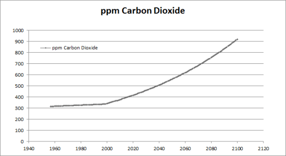
CO2 concentrations increase linearly from 1958 to 2000, and then exponentially until 2100, with a doubling of CO2 (with respect to 1958) around 2062. (This data was output as a spreadsheet, and I got Excel to generate the graph, so it looks nicer than the others.)
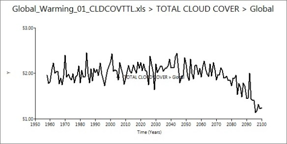
Global cloud cover held steady until around 2070, when it decreased. I can’t figure out why this would be, as the water vapour content of the air should be increasing with warming – wouldn’t there be more clouds forming, not less?
Global precipitation increased, as I expected. This is an instance where I wish the maps would have worked, because it would be neat to look at how precipitation amount varied by location. I’ve been pretty interested in subtropical drought recently.
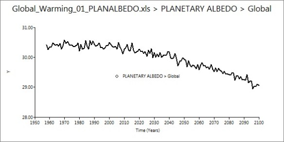
Albedo decreased about 1% – a nice example of the ice-albedo feedback (I presume) in action.
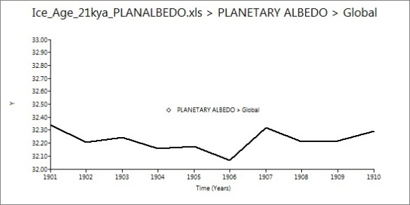
I also ran a simulation of the Last Glacial Maximum, from 21 thousand years ago. This run was much quicker than the first, as (since it was modeling a stable climate) it only simulated a decade, rather than 150 years. It took a few hours, and the same bugs in output were apparent. Time series graphs are less useful when studying stable conditions, but I found the albedo graph interesting:
Up a few percent from modern values, as expected.
It’s fairly expensive to purchase a licence for EdGCM, but they offer a free 30-day trial that I would recommend. I expect that it would run better on a Mac, as that’s what they do most of the software development and testing on.
Now that I’ve played around with EdGCM, I’m working on porting CESM to a Linux machine. There’s been trial and error at every step, but everything went pretty smoothly until I reached the “build” phase, which requires the user to edit some of the scripts to suit the local machine (step 3 of the user guide). I’m still pretty new to Linux, so I’m having trouble working out the correct program paths, environment variables, modules, and so on. Oh well, the more difficult it is to get working, the more exciting it is when success finally comes!
I am also doing lots of background reading, as my project for the summer will probably be “some sort of written something-or-other” about climate models. Steve has a great collection of books about climate change, and keeps handing me interesting things to read. I’m really enjoying The Warming Papers, edited by David Archer and Ray Pierrehumbert. The book is a collection of landmark papers in climate science, with commentary from the editors. It’s pretty neat to read all the great works – from Fourier to Broecker to Hansen – in one place. Next on my list is A Vast Machine by Paul Edwards, which I’m very excited about.
A quick question, unrelated to my work – why do thunderstorms tend to happen at night? Perhaps it’s just a fluke, but we’ve had a lot of them recently, none of which have been in the daytime. Thoughts?


Some good educational resources http://www.wunderground.com/education/education.asp
“Why do thunderstorms tend to happen at night?” Perhaps because some good neighbors have exceptional relationships with God? You know, good daytime weather for outdoor activities and stay inside at night.
I think this observation may not be true in general. It might be the case in a few geographical locations, which could definitely be influenced by global warning. See http://en.wikipedia.org/wiki/Thunderstorm Cumulous clouds need a lot of thermal energy and moisture to form, which may take several hours. The sun’s daytime radiation is the main heat source, so major thunderstorm activity will generally occur in late afternoon. But see the following paragraph in the above website:
“Typically, if there is little wind shear, the storm will rapidly enter the dissipating stage and ‘rain itself out’,[8] but if there is sufficient change in wind speed and/or direction the downdraft will be separated from the updraft, and the storm may become a supercell, and the mature stage can sustain itself for several hours.”
With today’s global warming, the mature stage may have a greater probability of sustaining itself long into the night.
Thunderstorms may have a lower probability of forming in Canada than in much of the United States, because of the higher southern temperatures, so it may be likely that more storms forming in the northern U.S. will persist into the night time and continue northward into Canada. A more significant question might be, “Are we receiving more thunderstorms now than in the past and maybe noticing that more of them happen to occur at night?”
Was the recent outbreak of thunderstorms and tornados in Massachusetts normal?
This 1974 study tends to agree with the observation that thunderstorms occur more frequently at night.
Click to access Wallace75.pdf
Again, unsourced observations from me: Here the thunderstorm activity has been such the early summer storms are usually earlier in the day, while the late summer storms have lasted further to the evening. Guessing the increased evaporation from the ground could be the reason for this. The cold front thunderclouds are pretty benign if the front passes in the morning and quite bad if it happens at 1700-2100 local time.
Regarding your question why there is less cloud formation. As the temperature of the troposphere increases it can hold more water vapor. There is a point where the whole troposphere may get so warm that no clouds form i.e. no condensation happens. As things get warmer the water vapor will start to ascend into the stratosphere. The stratosphere is generally colder than the troposphere. One can visualize that it starts to rain in the stratosphere and the rain re-evaporates in the troposphere.
This would be very unlikely but not impossible. This would be a way to vaporize the ocean in a so-called runaway greenhouse effect. Ultimately the H2O would break down into H2 and O2 and escape from the planet probably over millions of years. As stated highly unlikely.
Regarding lightning being more prevalent at night. Richard Feynman gas a good explanation in chapter 9 volume 2 of his Lectures on physics titled “Electricity in the Atmosphere”. I am almost sure that this has been improved upon but I do not know of any current publication. There is just too much going on in science to keep track of everything.
Generally speaking a thunderstorm depends on cloud formation which alters the dialectric characteristic of the atmosphere allowing lightning etc. In any given place the morning starts off cool and things heat up as the sun shines increasing evaporation and hence cloud formation and hence the likelyhood of a thunderstorm. As this takes time it will usually be afternoon or later that enough cloud formation has happened to allow a thunderstorm to form.
The whole thing is way more complicated than I can explain in a short update.
I recommend “A Vast Machine”, but beware that the author’s terminology is sometimes confusing. In particular, his term “model” seems to have several different connotations.
As for thunderstorms … Excuse me, I do not know the situation in Canada.
In the tropics, the peak time of occurrence of thunderstorms at majority of locations over land is in the afternoon, and that over ocean is after midnight. See for example
Chuntao LIU and Edward J. ZIPSER, 2008:
Diurnal cycles of precipitation, clouds, and lightning in the tropics
from 9 years of TRMM observations.
Geophysical Research Letters, Vol. 35, L04819, doi:10.1029/2007GL032437.
Click to access liu_zipser_2007GL032437.pdf
But, some locations over land have peaks at night. A good example is the area around Vientiane, the capital city of Laos. Case studies suggest that migrating mesoscale systems which consist of multiple cumulus clouds are responsible.
Takehiko SATOMURA, Keiko YAMAMOTO, Bounteum SYSOUPHANTHAVONG and Souvanny PHONEVILAY, 2011:
Diurnal variation of radar echo area in the middle of Indochina.
Journal of the Meteorological Society of Japan, Vol. 89A, 299-305.
http://www.jstage.jst.go.jp/article/jmsj/89A/0/89A_299/_article
In Japan, the diurnal modulation is weaker, than in the tropics but has the same sign, i.e. peak in the afternoon at the majority of location over land and after-midnight at some coastal locations.
Fumiaki FUJIBE, 1988:
Diurnal variations of precipitation and thunderstorm frequency in Japan in the warm season.
Papers in Meteorology and Geophysics, Vol. 39, No. 3, pp.79-94.
http://www.jstage.jst.go.jp/article/mripapers/39/3/39_79/_article
And, according to a recent data analysis, there is a centennial trend that the after-midnight peak is strengthened. (This is an analysis of the precipitation amount rather than thunderstorms, however. Also there is not yet discussions of the causes.)
Fumiaki FUJIBE, Nobuo YAMAZAKI and Kenji KOBAYASHI, 2006:
Long-term changes in the diurnal precipitation cycles in Japan for 106 years (1898-2003).
Journal of the Meteorological Society of Japan, Vol. 84, 311-317.
http://www.jstage.jst.go.jp/article/jmsj/84/2/84_311/_article
Re: your results of EdGCM. The “total cloud cover” is the fractional area of the earth which is covered by clouds (in percent as graphed), isn’t it? Then it is possible that it decreases while the total mass of cloud water increases, provided that vertically developing clouds (cumulus), rather than horizontally developing ones (stratus and cirrus), are becoming prevalent.
Yes, that makes sense. Thanks. -Kate
There are special Windows 7 updates for EdGCM that you install after the initial installation. These should allow you to produce maps.
Yes, I did that originally. No luck. -Kate
Also, storms do synchronize with the diurnal cycle. They don’t happen at night in general globally, but that might be a real pattern where you are. It is a function of local orography, evaporation sources, advection patterns, etc.
Clouds vs. temperature:
I’ll echo Masuda’s comment about cumulus vs. stratus development.
I’ll add, though, that the saturation vapor pressure increases super-exponentially with temperature. Even with more water in the atmospheric boundary layer, a warmer atmosphere may not condense this water in to clouds as readily. This should be more of a factor over the land, where the moisture source is more limited. So take a look in, say, central Asia, nicely removed from oceans, for a signal. Or to reject the hypothesis :-)
Evening thunderstorms:
I forget the source for the map, but I have seen a map of time of day for maximum frequency of thunderstorms over North America. It was old when I saw it in 1986, so some time-limited searching should turn it up. In any case, the gist was that along the Rockies and in the southeastern US, the peak was in late afternoon — call it 3-6 PM — with some geographic progression to the time, earliest in the west (on the Rockies) and later as you moved east from there. Then the reverse pattern as you approached Florida.
In between the two, say for Chicago and Toronto, there was a bimodal distribution. Afternoon peak from the usual convective reasons, and then a night-time peak from systems propagating in from the west.
penguindreams is probably thinking of Robert Maddox’s excellent 1980 BAMS article (doi: 10.1175/1520-0477(1980)0612.0.CO;2 ) on mesoscale convective complexes.
Hi Kate. What a lively comment thread. I envy you.
Davey, thanks for the cite. I couldnt get that DOI to resolve so i tracked down the article via google scholar and found it here:
http://journals.ametsoc.org/doi/abs/10.1175/1520-0477%281980%29061%3C1374%3AMCC%3E2.0.CO%3B2
“Unfortunately, as their Windows 7 support is fairly new, there were some bugs in the output. It refused to give me any maps at all!”
Upgrades. Gotta love ’em, they keep programmers roaming the streets at night.
Hi Kate, Trenberth et al. (2003, BAMS) has a nice figure (Fig. 3) that shows the diurnal cycle of JJA rainfall maxima in the U.S. East of the Rockies and over the plains, you can see a clear nighttime maximum. This nighttime maximum is attributable to the summertime low-level jet that flows northward from the Gulf of Mexico. Often times you can see big mesoscale convective complexes (MCCs) on satellite at night and early in the morning over these regions, and then these complexes typically dissipate rapidly during the day. From the figure, you can see that this nighttime maximum extends to the Canadian border, but I’m not sure how far north into Canada it extends.
Good luck with your project!
Kate:
If you have not already done so, you’ll want to check out “Models, On–and Off–the Catwalk – Part Three” posted on the Science of Doom website. Lots of interesting discussion occuring on the article’s comment thread as well.